Rex Sanders
Freelance science writer
rex.sanders
@USA.NET
Highlights -
About Rex -
Other Work
Highlights
Cruz Climate
Weekly newsletter starting October 2024

Climate change news and analysis for Santa Cruz County, California.
Plus what you can do, and the occasional good news.
Climate Jargon
ClimateJargon.com
Simple descriptions of unusual climate-related words, phrases, and acronyms.
Over 300 entries as of May 2025
Backpacking Jargon
BackpackingJargon.com
Backpacking: Camping and hiking while carrying almost everything needed in a backpack
Jargon: Words, phrases, or acronyms used by a group that are hard for others to understand
Backpacking Jargon: Simple explanations of jargon used by backpackers in America
Over 800 entries as of May 2025.
BatteryBench: A Protocol for Testing Portable Battery Chargers and Electronic Devices for Backpacking
Backpacking Light, December 2021
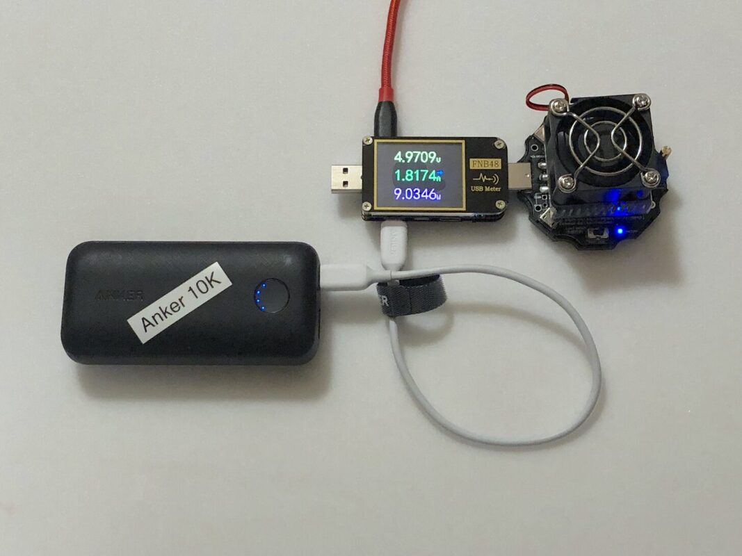
Some backpackers use a portable battery charger to keep other battery-powered devices running on longer trips. Portable battery chargers are also known as portable battery packs, battery banks, battery packs, portable chargers, portable power devices, portable power banks, power banks, or power packs.
It’s almost too easy to find tests and comparisons of portable battery chargers. But none that I read or watched focused on the most important factors that backpackers should care about, including the lightest models for charging your phone or earbuds.
Adapting to Changing Wildfires: Part Three
Backpacking Light, November 2020
This past summer and fall, wildfires in the Western U.S. seemed to set new records daily. News reports featured endless streams of scary images, incomprehensible statistics, and mysterious maps. But all of this told only part of the story.
NASA satellites with special infrared sensors capture images of fires every day. By animating those images, we can get a different look at how fast and how far wildfires grew in 2020.
Adapting to Changing Wildfires: Part Two
Backpacking Light, October 2020
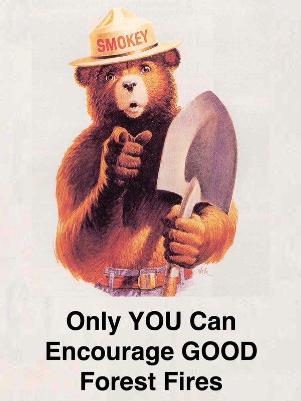
Wildfires in western North America have changed for the worse and will continue changing. Fire tornadoes ripped living trees out of the ground, set them alight, and dropped them miles away. Blazes consumed 400 square miles (1,000 square km) in one day. Researchers compared the worst wildfires to the firebombing of Dresden in World War II or Hiroshima’s destruction by an atomic bomb.
While reasonably cautious backpackers are unlikely to perish in wildfires, we must learn to live with altered fire behavior, landscapes, and rules. This essay is an exploration of what some of those changes might look like.
Adapting to Changing Wildfires: Part One
Backpacking Light, October 2020
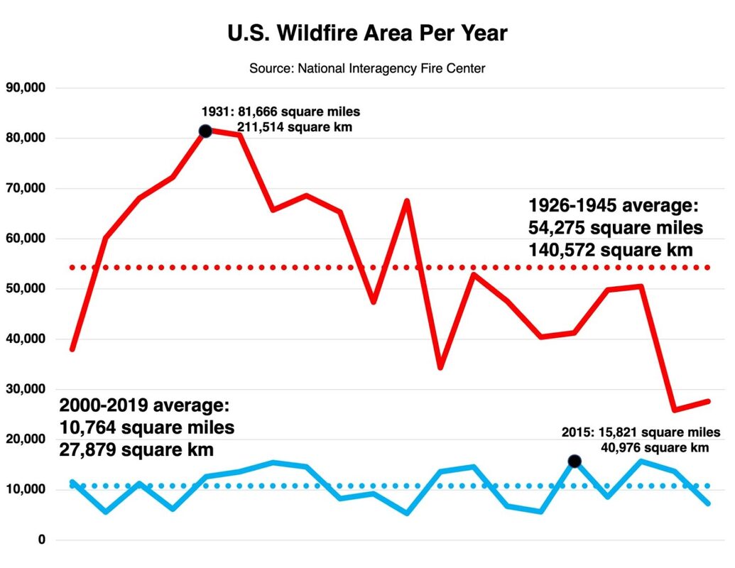
What is the future of backpacking in an era of frequent massive wildfires? This year’s giant blazes in the Western U.S. closed many thousands of square miles (tens of thousands of square kilometers) in forests and parks for weeks and months. This essay gives you some background on wildfires in the U.S., describes the potential health and safety risks, and suggests how to stay safer and healthier.
USGS Science in Point Reyes National Seashore
USGS, December 2016
The park also uses USGS science to manage this iconic but complex setting. For example, local ranchers lease 28,000 acres of National Park land for dairy and beef cattle. To monitor ranch lands, the park uses maps, air photos and other databases from USGS.
Condors in Purgatory
Science Notes, August 2015, multimedia
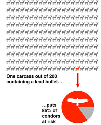
Swooping low across a canyon inside Pinnacles National Park, California condor #444 appeared to be in fine health. “Ventana” hatched in 2007 from a nest in Big Sur, and she paired five years later with #340. The next year they fed their first chick regurgitated food scavenged from miles away. That food came from a dead animal—rotting, stinking and crawling with maggots. But one of the condor’s favorite meals, the gut pile left behind after a hunter kills a deer or wild pig, threatens the survival of this critically endangered species.
↑Top
About Rex
Education and Experience
- University of California, Riverside, BS, Systems Ecology
- U.S. Geological Survey (USGS), 40 years
- Institute of Electrical and Electronics Engineers (IEEE) member, more than 40 years
- Part-time whitewater raft guide, 22 years, guide trainer, 19 years
- USGS Ask-A-Geologist project manager, 24 years
- Married to my smart, talented, beautiful wife, more than 25 years
- Backpacking Light columnist and author, 9 years
- University of California, Santa Cruz Science Communication Program, certificate (MS equivalent)
- Northern California Science Writers Association (NCSWA) member, more than 8 years
My USGS roles included:
- Applications and systems programmer using many platforms and languages
- Construction project manager
- IT support and manager
- Network engineer
- Open House producer
- Science writer, photographer, and videographer
- Scientific data manager
- Scientist
↑Top
Other work
Backpacking Light (BPL)
“Backpacking Light helps hikers and other backcountry enthusiasts overcome their barriers to living a life outside in Wild Places.”
Tent Fitting the Easy Way, Backpacking Light, March 2022
Portable Battery Chargers for Backpacking, Backpacking Light, March 2022 (video podcast)
BatteryBench: A Protocol for Testing Portable Battery Chargers and Electronic Devices for Backpacking, Backpacking Light, December 2021
Staff Picks 2021 (contributor), Backpacking Light, November 2021
Simple Gear Tests and USB Recharging, Backpacking Light, August 2021
Standards Watch Hikes into the Sunset, Backpacking Light, July 2021
Standards Watch: Mike Cecot-Scherer Talks Potty Trowels and More, Backpacking Light, June 2021
Backpacking First-Aid Philosophies, Backpacking Light, June 2021
The Backpacker’s Journey, Backpacking Light, June 2021
Standards Watch: Dan Durston Talks Design and Business, Backpacking Light, May 2021
Standards Watch: Dan Durston Chats About Standards and Testing, Backpacking Light, April 2021
You Know You’ve Been Backpacking a Long Time When…, Backpacking Light, April 2021
Standards Watch: Standards Are Important (But Not Enough), Backpacking Light, March 2021
Interview With Gear Creator Michael Glavin, Backpacking Light, February 2021
Standards Watch: Mike Cecot-Scherer on Tent Design, Backpacking Light, January 2021
Gratitude and Recovery After Outdoor Trauma, Backpacking Light, January 2021
Staff Picks 2020 (contributor), Backpacking Light, December 2020
Standards Watch: Tent Designer Mike Cecot-Scherer, Backpacking Light, December 2020
Standards Watch: Steve Seeber Interview, Backpacking Light, November 2020
Adapting to Changing Wildfires: Part Three, Backpacking Light, November 2020
Adapting to Changing Wildfires: Part Two, Backpacking Light, October 2020
Adapting to Changing Wildfires: Part One, Backpacking Light, October 2020
Sleeping Bag Temperature Ratings, Backpacking Light, October 2020 (video podcast)
GPS: The Good, the Bad, and the Ugly, Backpacking Light, October 2020
Sleeping Bag Temperature Ratings, Backpacking Light, September 2020
Improving R-values for Consumers, Backpacking Light, September 2020
Standards Watch: Introduction, Backpacking Light, September 2020
First, Buy a Smaller Pack, Backpacking Light, May 2020
More Reasons to Modify Gear, Backpacking Light, April 2020
Buy Less, Do More with Good Enough Gear, Backpacking Light, February 2020
Turn-by-Turn Directions for Simple Backpacking Navigation, Backpacking Light, January 2020
2019 Staff Picks (contributor), Backpacking Light, December 2019
Sleeping Pad R-values: Not That Useful, Backpacking Light, November 2019
Backpacking Scissors, Backpacking Light, February 2018
Rescue Insurance for Backpackers, Backpacking Light, January 2014
Backpacking With A Thermometer, Backpacking Light, October 2013
Backpacking With A Voice Recorder, Backpacking Light, October 2013
Satellite Texting, Backpacking Light, March 2013
Satellite Phones, Backpacking Light, March 2013
Two-way Satellite Communications for Backpacking, Backpacking Light, March 2013
↑Top
U.S. Geological Survey (USGS)
“Science for a Changing World”
Some links are broken due to frequent USGS web site changes.
Rising Seas and Storms Could Seriously Damage California’s Coast within 30 Years
Sound Waves, March 2019
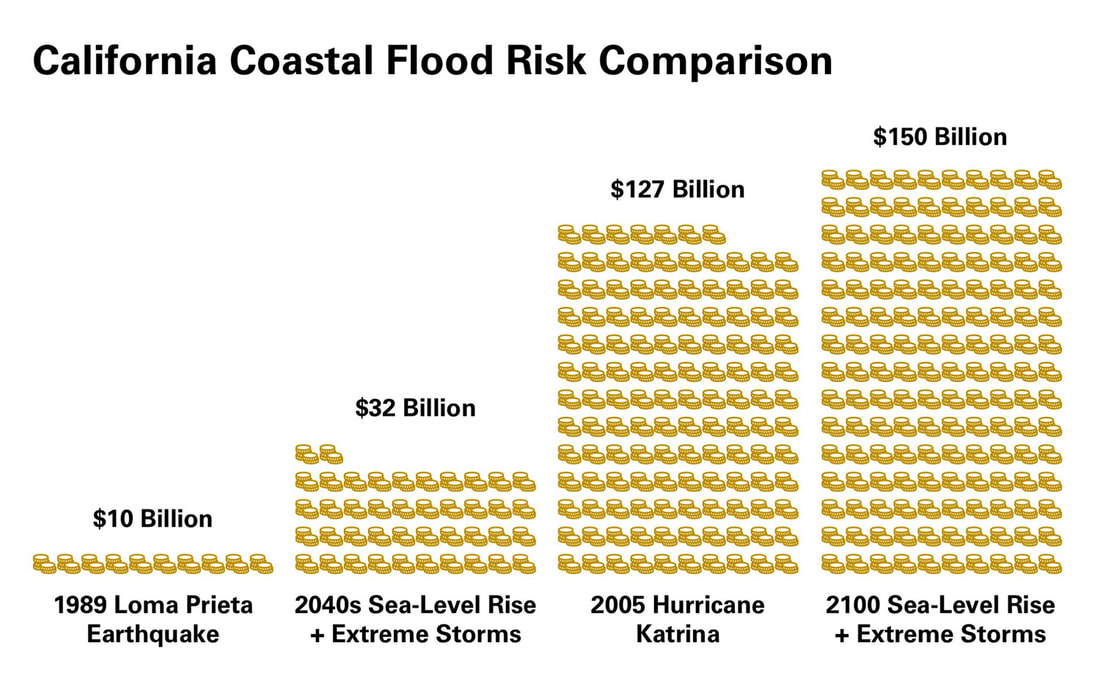
In less than 30 years the combination of 10 inches of sea-level rise plus an extreme storm along California’s coast could flood more than 150,000 residents and impact over $30 billion in property value. By 2100, when the oceans could be 6.6 feet higher, up to 600,000 people and $150 billion in property could be at risk from coastal flooding—potentially worse than Hurricane Katrina in destruction.
Giant Grooves Discovered on an Earthquake Fault Offshore Costa Rica
Sound Waves, February 2018
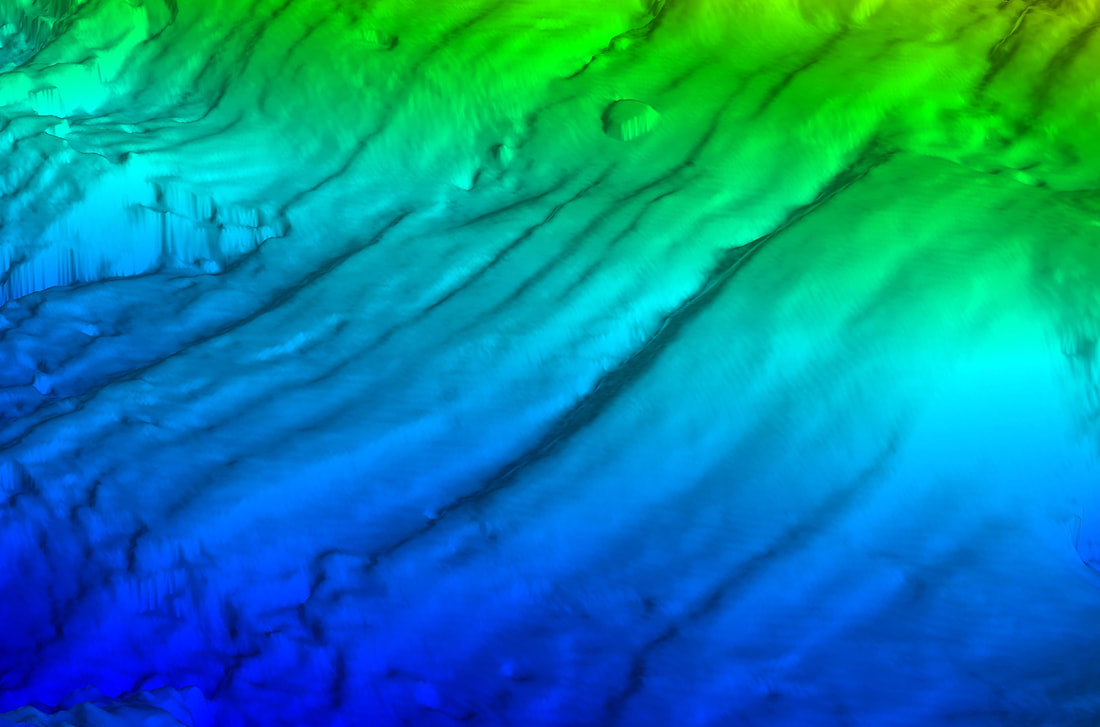
Imagine dragging your outstretched fingers through wet beach sand, leaving long grooves behind. Scientists recently discovered similar but enormous grooves buried under the seafloor near Costa Rica. The detailed three-dimensional data they used to uncover these corrugations can help them better understand large subduction zone earthquakes and related tsunamis worldwide.
Sound Waves columns
I pitched these columns, and wrote the first several articles.
News Briefs, every issue from December 2016 to July 2019
Short news snippets and one image from a wide range of USGS sources
Recent Fieldwork, every issue from December 2016 to July 2019
One line descriptions with a map of recent USGS coastal and marine field work
Photo Roundup, every issue from March to July 2019
Recent USGS coastal and marine images with extended captions
Social Media Highlights, March and May 2019
Reprints of selected recent USGS coastal and marine social media posts
Twitter
From 2016 to 2019, I wrote dozens of @USGS tweets,
and hundreds of @USGSCoastChange tweets.
Posters
Starting in 2004, I proposed, then created (with Laura Torresan) a dozen large posters explaining USGS coastal and marine geology research and capabilities for the general public:
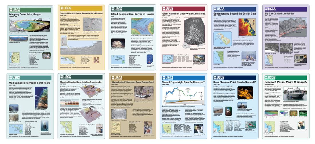
Mapping Crater Lake, Oregon, USGS
Tsunami Hazards in the Santa Barbara Channel, USGS
Island-hopping Coral Larvae in Hawaii, USGS
Giant Hawaiian Underwater Landslides, USGS
Oceanography Beyond the Golden Gate, USGS
Big Sur Coastal Landslides, USGS
Mud Damages Hawaiian Coral Reefs, USGS
Mapping Shipping Hazards in San Francisco Bay, USGS
Flying Eyeball Measures Grand Canyon Sand, USGS
Should Englebright Dam Be Removed?, USGS
Does Pleasure Point Need A Seawall?, USGS
Research Vessel Parke D. Snavely, USGS
Other USGS Products
Added Funding Aids Recovery from 2017 Hurricanes and Wildfires, Sound Waves, January 2019
Moving Mountains: Elwha River Still Changing Five Years After World’s Largest Dam-Removal Project, Sound Waves, September 2018
Pacific Missile Tracking Site Could Be Unusable in 20 Years Due to Climate Change, Sound Waves, February 2018
Polar Bears Film Their Own Sea Ice World (interview videographer), USGS, February 2018, video (YouTube)
A Tale of Two Tsunamis — Why Weren’t They Bigger? Mexico 2017 and Alaska 2018 (co-author), Sound Waves, February 2018
Open House Welcomes Enthusiastic Visitors to Santa Cruz Office, Sound Waves, January 2018
Also open house producer, director, troubleshooter, publicity manager, ...
Highlights from the 2017 AGU Fall Meeting, Sound Waves, January 2018
Busy Day in the Sed lab, USGS, July 2017, video (YouTube)
Scientists Inspiring Students, Sound Waves, May 2017
Bob Rosenbauer Retires as Science Center Director, Sound Waves, April 2017
Core and Sediment Labs, USGS, April 2017
New Director of Pacific Coastal and Marine Science Center, Sound Waves, April 2017
New Director of Woods Hole Coastal and Marine Science Center, Sound Waves, March 2017
Mystery Gap: Connecting Earthquake Faults near San Francisco, California, Requires Many Approaches (co-author), Sound Waves, February 2017
Long days, fresh ideas, and new connections: USGS scientists sharing science at the 2016 AGU Fall Meeting, USGS, December 2016
Coastal and Marine Scientists Talk About the AGU Fall Meeting, Sound Waves, December 2016
Looking for causes of underwater landslides near Santa Barbara, USGS, November 2016
B-roll Sampling and Coring in San Pablo Bay (editor), USGS, November 2016, video (YouTube)
Coral Reefs, El Niño, and Climate Change: An Interview with Lauren Toth, Sound Waves, May 2016
Preparing for El Niño Using Climate Change Forecasts, Sound Waves, May 2016
Local Research with Global Effects: Coastal Scientists Study El Niño in Northern California, Sound Waves, March 2016
Hurricane Sandy: Three Years Later, Sound Waves, January 2016
Twenty Years of Ask-A-Geologist, Sound Waves, October 2014
San Francisco Bay Sand and Mud, USGS, March 2014
Inspiring Girls to Pursue Careers in STEM, Sound Waves, August 2013
SODA – Self-Service Online Digital Archive for Unloved Scientific Data, in Geoinformatics 2007 – Data to Knowledge, May 2007
Ten Years of Ask-A-Geologist, Sound Waves, November 2004
USGS Monterey Bay Science: A Knowledge Bank Prototype, Sound Waves, November 2004
Making USGS Information Effective in the Electronic Age (co-author), Open-File Report, January 2003
CMG Program Data Management Workshop, Sound Waves, April 2001
Measurements of sand thicknesses in Grand Canyon, Arizona, and a conceptual model for characterizing changes in sand-bar volume through time and space (co-author), Open-File Report, January 1994
Internal structure of bars in Grand Canyon, Arizona, and evaluation of proposed flow alternatives for Glen Canyon Dam (co-author), Open-File Report, January 1994
↑Top
“We offer world-class training in science journalism.”
Classmates
Chris Cesare, www.chriscesare.com
Leigh Cooper, www.leighacooper.com
Kerry Klein, www.kerryklein.com
Lisa Marie Potter, lisamariepotter.com
Nala Rogers, nalarogers.pressfolios.com
Kim Smuga-Otto, kim.smuga-otto.com
James Urton, www.jamesurton.com
Nicholas Weiler, www.nicholasweiler.com
Leslie Willoughby, www.willoughbywriter.com
Internships
Stanford News Service, The Californian (Salinas), KUSP (closed), Point Reyes National Seashore
Products
Coastal Dune Restoration Project FAQs, Point Reyes National Seashore, October 2015
Condors in Purgatory, Science Notes, August 2015
Condors Continue to Suffer from Lead Poisoning, KUSP, August 2015, broadcast and online
Lead Ammunition Still Kills California Condors, UCSC Science Communication Program, July 2015, podcast and broadcast on KZSC
MBARI Team Earns XPRIZE to Measure Ocean Acidity, KUSP, July 2015, broadcast and online
One Hunter At A Time, UCSC Science Communication Program, June 2015, video
Keeping a Sanctuary Clean, KUSP, May 2015, broadcast and online
More oil trains may run through Monterey County, The Californian, March 2015, print and online
Shocking local statistics about sugary drinks, The Californian, March 2015, print and online
Good practices limit E. coli spread in lettuce fields, The Californian, March 2015, print and online
Investigators can’t identify source of E. coli outbreak, The Californian, February 2015, print and online
Pinnacles tops list of local quiet places, The Californian, February 2015, print and online
Praise, concern greet solar farm project in Monterey County, The Californian, February 2015, print and online
Methyl bromide phase-out impacts county’s top crop, The Californian, February 2015, print and online
Trash fees fund cleanup for illegal ag land dumping, The Californian, February 2015, print and online
Monterey County flu cases continue to climb, The Californian, January 2015, print and online
Water rights debated at EcoFarm conference, The Californian, January 2015, print and online
Study: Raindrops could spread pesticides, E. coli, The Californian, January 2015, print and online
Critical weather forecasting tool on Mount Umunhum might be in worst spot, San Jose Mercury News, Santa Cruz Sentinel, January 2015, print and online.
Also in the Oakland Tribune, InsideBayArea (Oakland), Monterey Herald, Contra Costa Times and The Reporter (Vacaville)
Living Deep in a Redwood Canyon, Out of the Fog, December 2014
Young Lava On The Moon, NASA Visualization Explorer, December 2014
Rocks: the larger they are, the faster they crumble, AGU GeoSpace, December 2014
Tracking wastewater in the ocean with satellites, AGU GeoSpace, December 2014
New evidence for a massive flood on the Mackenzie River 13,000 years ago, AGU GeoSpace, December 2014
Global warming's influence on extreme weather, Stanford News Service, December 2014
Stanford scientist examines ways to put stormwater to use in big cities, Stanford News Service, December 2014
Stanford d.school students 'humanize' a truck for a good cause, Stanford Report, December 2014
Seismic mystery: What’s causing the ground to rumble in Italy?, Science, December 2014
Old fishermen document declining range of the Indus River dolphin, Mongabay, December 2014
Stanford community shines at the Bay Area Science Festival, The Dish, November 2014
The Dark Side of California Sea Otters, Out of the Fog, November 2014
Stanford scholars tapped for quantum materials research grants, The Dish, November 2014
Girls under stress age more rapidly, new Stanford study reveals, Stanford Report, October 2014
Stanford researchers see trouble ahead for kindergarten students, Stanford Report, October 2014
Education and equality: The 2014 Tanner Lectures at Stanford, Stanford Report, October 2014
↑Top
Other
USGS-M Recollections, Multicians.org, late 1990s
Forecasting Pink Bollworm Emergence by Thermal Summation (co-author), Environmental Entomology, August 1977
↑Top
If the data you need still exists ...
Data management was an important part of my job for several decades. In 2012, while working for the U.S. Geological Survey (USGS) in Santa Cruz, California, I wrote this email and sent it to one coworker:
From: Rex Sanders <rsanders@usgs.gov>
Subject: Re: DM Quote
Date: July 23, 2012 at 4:52:42 PM PDT
Belated thanks. Quote's been percolating in my idea factory.
Here's a restatement:
If the data you need still exists …
If you found the data you need …
If you understand the data you found …
If you trust the data you understand …
If you can use the data you trust …
Someone did a good job of data management.
I prefer more positive statements.
-- Rex
Excellent science depends on excellent data management.
On Jul 5, 2012, at 11:22 AM, (Coworker) wrote:
I can't integrate what I can't find.
I can't use something I don't understand.
I don't want to use something I don't trust.
I can't use something that isn't there any more.
- 2010 NGC Workshop Report
She added my version to the new USGS Data Management home page:
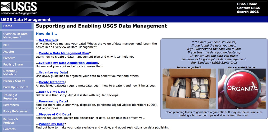
The words stayed there just a few months until a web site redesign.
Yet I got emails asking about this for years.
↑Top
Updated 2025 May 9
https://rexsanders.com


